


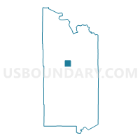
Unorg. Prct. 10, St. Louis County, Minnesota
About
Outline

Summary
| Unique Area Identifier | 604218 |
| Name | Unorg. Prct. 10 |
| County | St. Louis County |
| State | Minnesota |
| Area (square miles) | 36.30 |
| Land Area (square miles) | 36.14 |
| Water Area (square miles) | 0.16 |
| % of Land Area | 99.55 |
| % of Water Area | 0.45 |
| Latitude of the Internal Point | 47.74542520 |
| Longtitude of the Internal Point | -92.51911630 |
Maps


Graphs
Select a template below for downloading or customizing gragh for Unorg. Prct. 10, St. Louis County, Minnesota


Neighbors
Neighoring Voting District (by Name) Neighboring Voting District on the Map
- Angora Twp. Voting District, St. Louis County, MN
- Greenwood Twp. Voting District, St. Louis County, MN
- Owens Twp. Voting District, St. Louis County, MN
- Sandy Twp. Voting District, St. Louis County, MN
- Unorg. Prct. 13, St. Louis County, MN
- Unorg. Prct. 15, St. Louis County, MN
- Vermilion Lake Twp. Voting District, St. Louis County, MN
Top 10 Neighboring County Subdivision (by Population) Neighboring County Subdivision on the Map
- Sand Lake UT, St. Louis County, MN (1,066)
- Greenwood township, St. Louis County, MN (939)
- Sandy township, St. Louis County, MN (356)
- Vermilion Lake township, St. Louis County, MN (278)
- Owens township, St. Louis County, MN (263)
- Angora township, St. Louis County, MN (249)
- Northeast St. Louis UT, St. Louis County, MN (248)